21.04.2026
First part of the long-term lava hazard assessment for the Reykjanes Peninsula published
The reports form part of a comprehensive assessment of volcanic hazards across the peninsula.
Key findings on lava hazards
- The long-term lava hazard assessment identifies potential eruption sites and areas that could be exposed to lava flows, based on the region’s eruption history.
- The assessment is not intended to predict where or when the next eruption will occur, or whether lava will flow across a particular area in the coming years.
- Its main objective is to reduce damage, with an emphasis on infrastructure. The findings provide important input for settlement planning and land use.
- Two towns, four power plants and two water supply sources lie within the areas ranked in the highest 10% for lava hazards on the Reykjanes Peninsula.
- The scenarios presented in the reports show that most existing development in the capital region lies in areas where the likelihood of lava inundation is assessed as “very low” or “low”.
- The findings support existing knowledge rather than fundamentally changing our understanding of lava hazards to communities and infrastructure on the Reykjanes Peninsula.
- Alongside the reports, the Icelandic Meteorological Office has launched a website and an interactive map viewer.
About the volcanic hazard assessment
- The two reports published today form part of an extensive project by the Icelandic Meteorological Office to assess volcanic hazards comprehensively across the Reykjanes Peninsula.
- Four reports have now been published as part of the project, which began in early 2024 and is scheduled for completion in 2027. Four reports on ground-fracturing hazards, two further lava hazard reports and one earthquake hazard report will be added this year.
- Reports on tephra fall, volcanic gas pollution and groundwater contamination will follow next year.
- Bringing together volcanic hazard assessments in a single project for an area containing seven volcanic systems, sixteen municipalities and extensive critical infrastructure is unique on a global scale.
- The long-term hazard assessment does not determine what constitutes “acceptable risk” for living or operating in the area. It does, however, provide a basis for that discussion and for decision-making.
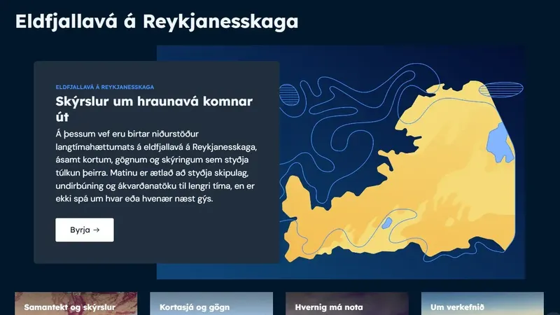
New website for volcanic hazards on the Reykjanes Peninsula
The reports published today can be downloaded from a new website dedicated to volcanic hazards on the Reykjanes Peninsula. The website is designed to help users read and interpret the project’s findings. It also provides access to a map viewer where users can explore maps from the reports and download map layers and geospatial data.
Detailed findings on areas exposed to lava hazards
Most of the Reykjanes Peninsula is covered by older lava flows. Seven volcanic systems, extending from Reykjanestá in the west to Ölfusá in the east, have shaped its landscape. The scenarios presented in the reports published today are based on geological data incorporated into numerical models. The results are used to assess the relative likelihood of eruption sites and identify areas exposed to lava inundation.
The purpose of the long-term lava hazard assessment is to identify exposed or vulnerable areas, rather than predict the precise course of the next possible event. The findings show where eruptions are more likely to originate and where lava flows could have an impact.
“When examining the findings, it is very important to understand that we are not saying the scenarios presented will necessarily occur,” says Bergrún Arna Óladóttir, a volcanologist at the Icelandic Meteorological Office.
“The results do not tell us where or when the next eruption will occur, or whether lava will flow across a particular area in the coming years. What we now have is a comprehensive overview providing detailed information about areas exposed to lava hazards. The findings will be useful to spatial planners, operators of critical infrastructure and emergency responders, including when updating contingency plans,” says Bergrún.
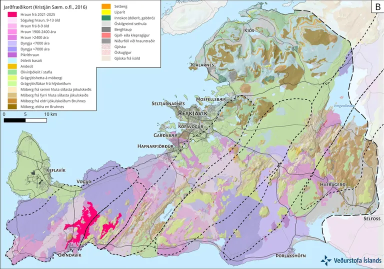
Geological map of the Reykjanes Peninsula (Kristján Sæmundsson et al., 2016), with lava flows from 2021–2025 added. The seven volcanic systems are outlined with dotted lines. They differ in size and in the number of known lava flows, suggesting differences in their eruptive productivity and intensity.
The likelihood of eruption sites is based on the region’s eruption history
- Eruption sites are most likely to occur in the central parts of the volcanic systems and where the systems intersect the plate boundary on the Reykjanes Peninsula.
- Grindavík is the only town close to an area with a high likelihood of eruption sites.
- All power plants on the Reykjanes Peninsula—Reykjanes, Svartsengi, Hellisheiði and Nesjavellir—are situated in areas where the likelihood of eruption sites is assessed as moderate to very high.
Two key factors must be considered when assessing hazards from lava-producing eruptions: where an eruption may begin and the likelihood of lava inundating the surrounding land.
The relative likelihood of future eruption sites—that is, the likelihood of an eruption beginning at a particular location—was assessed using a numerical model. The modelling draws on knowledge of the region’s eruption history and geology. Different weights are assigned to eruptive fissures, young hyaloclastite ridges, high-temperature geothermal areas, other fractures and the plate boundary. Locations where the geological record shows repeated eruption sites receive the greatest weight.
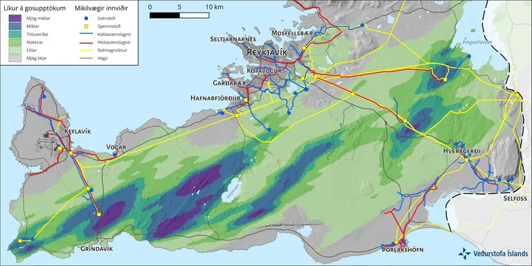
Relative likelihood of eruption sites, calculated using a numerical model based on the region’s eruption history and geology. Darker colours indicate a higher likelihood than lighter colours. For example, areas classified as “high likelihood” are ten times more likely to host an eruption site than areas classified as “low likelihood”. Uncoloured areas, shown in grey, have a very low likelihood. The assessment does not estimate how likely an eruption is to occur in a particular area in the coming years.
The long-term assessment does not replace the current hazard assessment for activity at Svartsengi
The long-term hazard assessment must not be confused with the short-term assessments issued regularly in response to activity at Svartsengi and the Sundhnúkur crater row. The short-term assessment addresses what could happen in the near future and is based on the latest monitoring data and information about activity in the area. For example, that assessment currently indicates a low hazard of eruption onset within Svartsengi.
The map above shows the relative likelihood of eruption sites across the entire Reykjanes Peninsula. It indicates whether an eruption site is more likely in one area than another. As the report explains, eruption sites are more likely in the central parts of volcanic systems and where they intersect the plate boundary, as at Svartsengi.
Where the long-term map indicates a “high” likelihood of eruption sites, this means that eruption sites are ten times more likely there than in areas classified as having a “low” likelihood. The assessment does not estimate whether or where an eruption will occur on the peninsula in the coming years; it assesses only where an eruption is more likely to begin relative to other locations.
When a volcanic system shows activity comparable to that observed at Svartsengi, the long-term assessment is superseded by a short-term assessment based on real-time data. For the Svartsengi and Grindavík area, the short-term assessment therefore takes precedence over the long-term assessment.
Four scenarios identify areas potentially exposed to lava flows
- The findings support existing knowledge rather than fundamentally changing our understanding of lava hazards to communities and infrastructure on the Reykjanes Peninsula.
- Three towns on the peninsula lie in areas where the likelihood of lava inundation is assessed as moderate to very high.
- Most existing development in the capital region lies in areas classified as having a very low or low likelihood of lava inundation, even under the scenario with the most extensive impacts.
- The maps combine lava inundation likelihoods from all seven volcanic systems across the peninsula. They do not represent a single event or predict specific future events.
Long-term lava hazard assessments draw on knowledge of volcanic activity and lava flows in the region being studied. The characteristics of lava emerging from an eruption site—including effusion rate, flow velocity, the development of lava transport pathways, cooling and cooling rate—together with the underlying terrain determine the type of lava flow that forms and the hazards it poses. Eruptions on the Reykjanes Peninsula have produced both lava flows that travelled considerable distances from their sources and flows that mainly accumulated and thickened closer to the eruption sites.
Four lava-flow scenarios are presented. The scenarios and the settings used in the lava-flow model are based on experience from eruptions in the Fagradalsfjall and Svartsengi volcanic systems between 2021 and 2024. The model simulates the behaviour of lava produced by such eruptions.
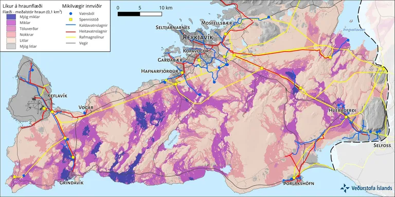
Each scenario presented in the reports combines the results of numerous simulations. This scenario, “Flow—medium-sized lava flows”, produces the most extensive impacts. Darker colours indicate a higher likelihood of lava inundation than lighter colours. The assessment does not estimate how likely lava is to inundate a particular area in the coming years.
Models reproduce known lava-flow routes towards the capital region
The scenario with the most extensive impacts shows that most existing development in the capital region lies in areas where the likelihood of lava inundation is assessed as “very low” or “low”. The models also reproduce known lava-flow routes towards the capital region from previous eruptions in two volcanic systems on the Reykjanes Peninsula: Krýsuvík and Brennisteinsfjöll.
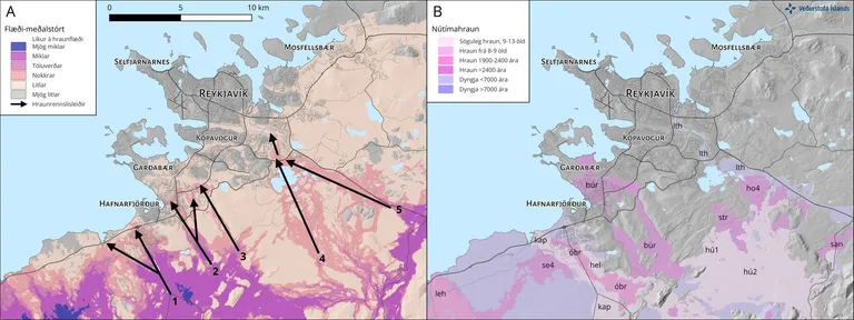
Most existing development in the capital region lies in areas where the likelihood of lava inundation is assessed as “very low” or “low”. Comparing the maps shows that the modelling reproduces known lava-flow routes towards the capital region. The map on the right shows lava flows from previous eruptions that reached the capital region. The map on the left shows potential lava-flow routes calculated for the scenario with the most extensive impacts, “Flow—medium-sized lava flows”.
Where are lava hazards greatest on the Reykjanes Peninsula?
- Two towns, Grindavík and Hveragerði, lie within the highest lava hazard category: the highest-ranked 10% of areas.
- Grindavík is exposed both to a very high likelihood of lava inundation and a very high likelihood of eruption sites. Hveragerði’s position is different: it falls within the highest category solely because of lava inundation.
- Part of Hafnarfjörður lies approximately one kilometre from areas in the highest lava inundation hazard category.
- Critical infrastructure is also located within the highest hazard category, including four power plants and two water supply sources.
Lava hazards on the Reykjanes Peninsula are greatest where the likelihood of eruption sites, lava inundation, or both is highest. The peninsula-wide lava hazard report identifies these highest-ranked areas. They comprise the highest-ranked 10% of potential impact areas for lava inundation, eruption sites, or both.
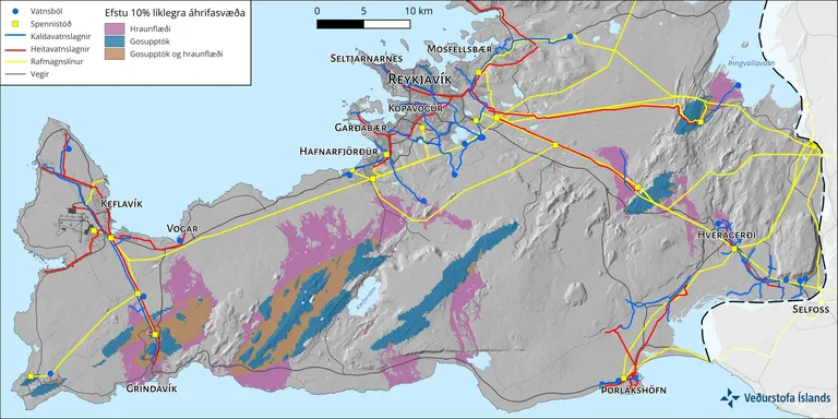
Areas in the highest lava hazard category on the Reykjanes Peninsula: the highest-ranked 10% of potential impact areas for lava inundation in pink, eruption sites in blue, or both in brown.
A website and map viewer to make the findings easier to use
Alongside the reports published today, the Icelandic Meteorological Office is launching a new website and interactive map viewer. The website is designed to help users read and interpret the project’s findings. The map viewer provides interactive access to maps, including different lava hazard scenarios and potential impact areas.
Website: www.eldfjallava.is
Map viewer: eldfjallava.vedur.is
Professionals can download map data for use in spatial planning and infrastructure design. More material will be added to the website and map viewer as further project reports are published. The website forms part of the Icelandic Meteorological Office’s work to improve access to, and presentation of, data relating to natural hazard and risk assessments in Iceland.
“Establishing a comprehensive volcanic hazard assessment of this kind is important. In a country like ours, exposed to significant natural hazards, society needs to be well prepared and informed about the hazards that may arise. Assessing natural hazards is complex, but the results must be useful and accessible to as many people as possible. Clear presentation and good access to digital data are key,” says Haukur Hauksson, Communications Director at the Icelandic Meteorological Office.
“This website is part of the Icelandic Meteorological Office’s new website, where we are working to improve the presentation of information that helps us live with natural hazards and plan to reduce our exposure,” says Haukur.
The reports published today form part of a comprehensive volcanic hazard assessment
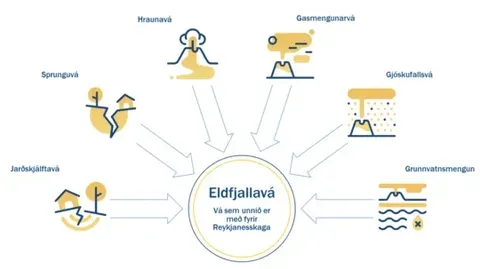
Volcanic hazards on the Reykjanes Peninsula comprise several components, each of which can affect communities and infrastructure. The diagram shows the six components covered by the assessment.
For this project, the Reykjanes Peninsula is defined broadly, extending from Reykjanestá in the west to Ölfusá in the east and Hvalfjörður in the north. Sixteen municipalities lie partly or entirely within the study area, which is divided into three regions:
- The capital region: Garðabær, Hafnarfjörður, Kjósarhreppur, Kópavogur, Mosfellsbær, Reykjavík and Seltjarnarnes.
- Western Árnessýsla: Árborg, Bláskógabyggð, Grímsnes- og Grafningshreppur, Hveragerði and Ölfus.
- Suðurnes: Grindavík, Reykjanesbær, Suðurnesjabær and Vogar.
In addition to the peninsula-wide lava hazard report, each of the three regions will be covered in a separate report. The lava hazard reports for Suðurnes and western Árnessýsla will be published later this year.
Four reports have now been published as part of the project, which began in early 2024 and is scheduled for completion in 2027. Four reports on ground-fracturing hazards, the two further lava hazard reports mentioned above and one earthquake hazard report will be added this year. Reports on tephra fall, volcanic gas pollution and groundwater contamination will follow next year
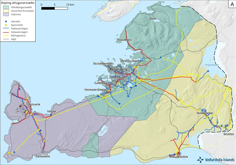
The Reykjanes Peninsula as defined for the project, divided into three regions: 1) the capital region in green, 2) western Árnessýsla in yellow, and 3) Suðurnes in blue-grey. Reports covering lava hazards across the entire peninsula and in the capital region were published today. Reports for Suðurnes and western Árnessýsla will follow later this year.
The importance of discussing volcanic hazards and “acceptable risk”
The lava hazard findings support decision-making by providing location-specific likelihoods that indicate how exposed each place is to lava inundation. They provide guidance for informed decisions on spatial planning and appropriate land use.
The Grindavík Committee has presented a framework plan for rebuilding Grindavík, with an emphasis on safety, residents’ well-being and the community’s long-term recovery. The plan highlights the need to define acceptable risk, draw on professional risk assessments in accordance with international standards, and develop a clear framework for eruptions and crustal movements comparable to the existing framework for avalanches and landslides.
“The long-term hazard assessment does not determine what constitutes ‘acceptable risk’ for living or operating in the area. It does, however, provide a basis for that discussion and for decision-making,” says Hildigunnur H. H. Thorsteinsson, Director General of the Icelandic Meteorological Office.
“We envisage the long-term lava hazard assessment for the Reykjanes Peninsula supporting spatial planning for the benefit of society and providing a foundation for informed decision-making. Current planning regulations require natural hazards to be taken into account, but do not clearly specify where development is permitted, where it is not, or where mitigation measures are required, as legislation and regulations do for avalanches and landslides. This work is therefore a contribution to a wider discussion with the government and planning authorities about how to incorporate these considerations into the planning framework,” says Hildigunnur.
A project with few international precedents
The two reports published today form part of an extensive project by the Icelandic Meteorological Office to assess volcanic hazards comprehensively across the Reykjanes Peninsula.
In early 2024, the Ministry of the Environment, Energy and Climate commissioned the Icelandic Meteorological Office to prepare a long-term risk assessment for earthquakes, volcanic eruptions and other geological hazards on the peninsula. The decision followed increased activity in the region and reflected priorities identified in a report on natural hazards in Iceland published in April 2023.
Four reports have now been published as part of the project, which is scheduled for completion in 2027. Four reports on ground-fracturing hazards, two further lava hazard reports and one earthquake hazard report will be added this year. Reports on tephra fall, volcanic gas pollution and groundwater contamination will follow next year.
Bringing together volcanic hazard assessments in a single project for an area containing seven volcanic systems, sixteen municipalities and extensive critical infrastructure has few international precedents.
“It is also unusual on a global scale for more than half a nation’s population to live in an area containing seven volcanic systems. But the proximity of large communities to volcanoes reflects the fact that they provide valuable natural resources that we want to continue accessing and benefiting from,” says Matthew J. Roberts, Executive Director of Services and Research at the Icelandic Meteorological Office.
“Given the possibility of volcanic activity on the Reykjanes Peninsula over the coming decades, the project’s outputs are extremely valuable. They will help us make informed decisions ahead of time rather than react to unexpected events,” says Matthew.
Around twenty specialists at the Icelandic Meteorological Office contribute to the project in various ways. Since the project began, six eruptions have occurred along the Sundhnúkur crater row.
“The Ministry of the Environment, Energy and Climate and the government have provided strong support to the Icelandic Meteorological Office throughout these events on the Reykjanes Peninsula. Carrying out such an extensive project alongside six eruptions, lasting more than 200 days in total, has been challenging. The same people are working on the hazard assessment and responding to the eruptions,” says Hildigunnur.
“But these events and this project are generating a great deal of knowledge. Given the possibility of volcanic activity on the Reykjanes Peninsula over the coming decades, it is important to have these findings now, so that informed decisions can be made in advance rather than under time pressure when unexpected events occur,” says Hildigunnur.
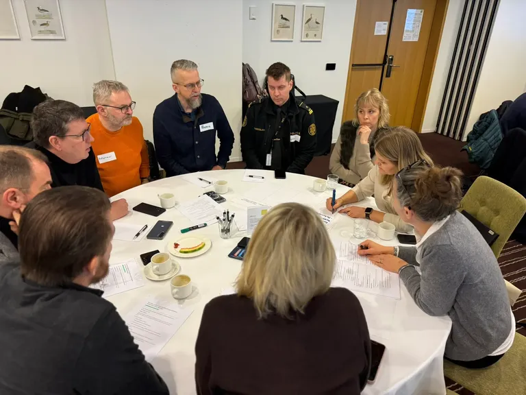
Hildigunnur, Director General of the Icelandic Meteorological Office, at a stakeholder workshop held in January 2026. Around 100 people attended, including emergency responders, municipal planning officers and representatives of companies operating critical infrastructure on the peninsula. The workshop’s main objective was to discuss how data access and presentation could best support stakeholders’ decision-making.
Further information about the long-term lava hazard assessment
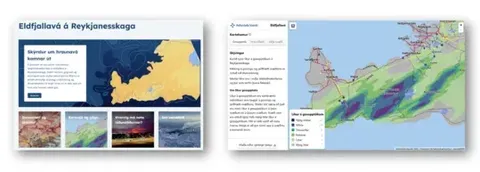
Screenshot of eldfjallava.is and its map viewer.
Further information about the reports published today is available at www.eldfjallava.is.
Maps from the reports can also be explored and data downloaded through the interactive map viewer.
Key findings on lava hazards
About the volcanic hazard assessment
Detailed findings on areas exposed to lava hazards
The likelihood of eruption sites is based on the region’s eruption history
The long-term assessment does not replace the current hazard assessment for activity at Svartsengi
Four scenarios identify areas potentially exposed to lava flows
Models reproduce known lava-flow routes towards the capital region
Where are lava hazards greatest on the Reykjanes Peninsula?
A website and map viewer to make the findings easier to use
The reports published today form part of a comprehensive volcanic hazard assessment
The importance of discussing volcanic hazards and “acceptable risk”
A project with few international precedents