Home-page - Icelandic Meteorological Office
Weather forecast
Weather forecast for the next 24 hours
Light easterly or variable wind. Mainly dry with sunny periods. Temperature 4 to 12 deg. C during the day.
North 3-8 m/s tomorrow. Partly cloudy or fair in the south and west. Mostly cloudy in North- and East-Iceland and a bit colder than today.
Forecast made 24.04.2024 15:09
If the map and the text forecast differs, then the text forecast applies
Forecast for station - 1
Forecast for station - 2
Forecast for station - 3
Forecast for station - 4
Forecast for station - 5
Maximum wind in Iceland today
| Lowlands | |
|---|---|
| Highlands | |
|---|---|
Maximum and minimum temperature in Iceland today
| Lowlands | |
|---|---|
| Highlands | |
|---|---|
Maximum precipitation in Iceland today
| Lowlands | |
|---|---|
| Highlands | |
|---|---|
Maximum wind in Iceland during the last hour
| Lowlands | |
|---|---|
| Highlands | |
|---|---|
Maximum and minimum temperature in Iceland during the last hour
| Lowlands | |
|---|---|
| Highlands | |
|---|---|
Maximum precipitation in Iceland during the last hour
| Lowlands | |
|---|---|
| Highlands | |
|---|---|
Preliminary results
Earthquakes
Earthquakes during last 48 hours. at 24 Apr 17:50 GMT


Biggest earthquakes during the last 48 hours
| Size | Time | Quality | Location |
|---|---|---|---|
| 2.4 | 23 Apr 05:26:52 | Checked | 3.4 km NE of Geirfuglasker |
| 2.0 | 24 Apr 00:39:27 | Checked | 13.1 km SSW of Eldeyjarboði |
| 1.9 | 24 Apr 01:00:26 | Checked | 2.7 km E of Goðabunga |
Specialist remark
Eruption in Sundhnúkur crater row
The volcanic eruption at Sundhnúksgígar continues at a similar rate with one crater erupting.
See news article
Information about gas pollution forecast is
available here
Written by a specialist at 24 Apr 01:58 GMT
Week overview -
Earthquake activity throughout the country is described in a weekly summary that is written by a Natural Hazard Specialist. The weekly summary is published on the web every Tuesday. It covers the activity of the previous week in all seismic areas and volcanic systems in the country. If earthquake swarms are ongoing or significant events such as larger earthquakes have occurred during the week, they are specifically discussed. More
Hydrology
Average flow and temperature last 24 hours
| River | Place | Flow | Water temperature |
|---|
Avalanches
Avalanche bulletins for selected areas
The avalanche bulletin is at a regional scale. It does not necessarily represent avalanche danger in urban areas.
| Region | Tue Apr 23 | Wed Apr 24 | Thu Apr 25 |
|---|---|---|---|
|
Southwest corner
|
|
|
|
|
Northern Westfjords
|
|
|
|
|
Tröllaskagi
|
|
|
|
|
Eyjafjörður (experimental)
|
|
|
|
|
Eastfjords
|
|
|
|
News
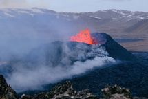
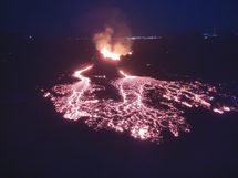
The eruption continues in Sundhnúkur crater row
Updated 23. April at 18:00 UTC
The eruption continues from the single vent which formed just East of Sundhnúkur, in a similar manner since 5 April. Lava continues to extrude and propagate towards the South along open channels, which are clearly visible from the cameras. The lava is also travelling longer distances from the crater through a network of closed tubes, which prevents the lava from cooling by direct contact with the atmosphere. The sector of the lava field which has been propagating towards the South, and reached the protective barriers built East of Grindavík town, has been thickening in the past few days, as shown in the images below. The images show the differences in the lava field profile between 18 and 23 April. The image at the top is taken from the camera owned by the Icelandic Civil Protection which is located at the barrier East of Grindavík and looks toward the part of the lava field which propagated towards Suðurstandavegur at the beginning of the eruption. The image at the bottom is also from a camera owned by the Icelandic Civil Protection and it is located on top of Hagafell hill and is oriented to the South.
Read more
One month since the start of the eruption at the Sundhnúkur crater row
Today marks one month since the beginning of the eruption that is ongoing at the Sundhnúkur crater row. The eruption, which began on the evening of March 16, is the fourth in a series of eruptions that started when magma began accumulating beneath Svartsengi in late October 2023.
Read more
Seismic swarm in the northwest past of the caldera in Askja yesterday
Yesterday (25 March) a seismic swarm occurred in the NW part of the Askja caldera. About 30 earthquakes were detected between 08.00UTC and midday. The largest earthquake detected had a magnitude M3,5 at a depth of about 5 km. Three earthquakes with magnitudes between M2 and M2,5 were also detected, the rest of the activity was characterized by smaller events. Overall, the seismic activity in the Askja has been quite stable between months and unchanged until yesterday. Looking back, we can see that earthquakes with magnitude above M3 were detected in January 2022 and October 2021.
Read moreThe weather in Iceland in 2023
The weather in 2023 was mostly favorable. It was calm, dry, relatively little snow and stormy days were quite uncommon. However, the year was cooler compared to the most recent years. The average nationwide temperature was 0.1°C colder than the average temperature between 1991 and 2020, and 0.4°C colder than the average temperature of the last ten years. It was relatively coldest in the North, while the Southwest and Southern coast were relatively warmer. The weather was particularly cold in the beginning of the year and again in March. June, on the other hand was exceptionally warm in the North and East. It was the warmest June on record in many places in those regions. The year was relatively dry, with precipitation below average across most of the country. There were several dry periods during the year, such as in March and July, but there were also periods of heavy rain in between. May and June were particularly wet and gloomy in the southern and western regions.
Read more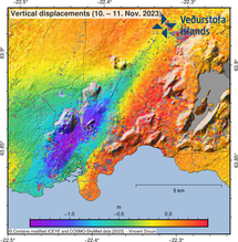
New understanding of ultra-rapid formation of magma filled cracks in the Earth
On 10 November 2023 the town of Grindavík in Iceland was evacuated as massive amounts of magma suddenly flowed into a magma filled crack that propagated underneath the town. Magma was emplaced in a 'vertical sheet' type intrusion in the Earth's crust. An international team of scientists explains the formation of the intrusion, and conditions for ultra-rapid flow into cracks, in a new publication in the prestigious scientific journal Science.
Read more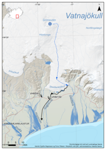
Conclusion of Grímsvötn Glacial Outburst Flood
Updated 23 January at 9:00 UTC
Since the glacial flood reached its peak in the river Gígjukvísl approximately a week ago, the water level has been decreasing and is now comparable to what it was before the flood. The seismic tremor measured on the seismometer at Grímsfjall has also declined, with seismic noise now back to normal levels. Since last week Monday, 21 earthquakes have been recorded in Grímsvötn, including two earthquakes exceeding magnitude two.
Read moreShort articles
Icelandic climate
Iceland enjoys a much milder climate than its name and location adjacent to the Arctic circle would imply.
Read moreNew publications and research
- Michelle Parks, Freysteinn Sigmundsson, Vincent Drouin, Ásta R. Hjartardóttir, Halldór Geirsson, Andrew Hooper, Kristín S. Vogfjörð, Benedikt G. Ófeigsson, Sigrún Hreinsdóttir, Esther H. Jensen, Páll Einarsson, Sara Barsotti & Hildur M. Friðriksdóttir. (2023).
- Sahar Rahpeyma, Benedikt Halldórsson, Birgir Hrafnkelsson & Atefe Darzi. (2023). Frequency-dependent site amplification functions for key geological units in Iceland from a Bayesian hierarchical model for earthquake strong-motions.
- Sara Klaasen, Solvi Thrastarson, Yesim Cubuk-Sabuncu, Kristín Jónsdóttir, Lars Gebraad, Patrick Paitz & Andreas Fichtner. Subclacial volvano monitoring with fiber-optic sensing: Grímsvötn, Iceland. (2023).
- Ismael Vera Rodriquez, Marius P. Isken, Torsten Dahm, Oliver D. Lamb, Sin-Mei Wu, Sigríður Kristjánsdóttir, Kristín Jónsdóttir, Pilar Sanchez-Pastor, John Clinton, Christopher Wollin, Alan F. Baird, Andreas Wuestefeld, Beat Booz, Eva P.S.Eibl, Sebastian Heimann, Bettina P. Goertz-Allmann, Philippe Jousset, Volker Qye, Vala Hjörleifsdóttir, Anne Obermann. (2002).
- Lamb, O.D., Gestrich, J.E., Barnie, T.D., Jónsdóttir, K., Ducrocq, C., Shore, M.J., Lees, J.M., Lee, S.J (2022). Acoustic observations of lava fountain activity during the 2021 Fagradalsfjall eruption, Iceland. Bull Volcanol 84, 96. doi.org/10.1007/s00445-022-01602-3
- Freysteinn Sigmundsson, Michelle Parks, Andrew Hooper, Halldór Geirsson, Kristín S. Vogfjörd, Vincent Drouin, Benedikt G. Ófeigsson, Sigrún Hreinsdóttir, Sigurlaug Hjaltadóttir, Kristín Jónsdóttir, Páll Einarsson, Sara Barsotti, Josef Horálek & Thorbjörg Ágústsdóttir (2022). Deformation and seismicity decline before the 2021 Fagradalsfjall eruption. Nature 609, 523–528. doi.org/10.1038/s41586-022-05083-4
Search
Contact IMO
© Veðurstofa Íslands | Bústaðavegi 7- 9 | 105 Reykjavík | Phone 522 6000 | Fax: 522 6001
Recording 902 0600 | SSN 630908-0350
Contact us | Employees | Terms and conditions | Sitemap